LANDSCAPE, FUTURE CORRIDORS AND URBAN GROWTH IN MEDIUM CITIES. FOUR CASES IN CASTILLA Y LEÓN,
(Valladolid, Segovia, Palencia & Zamora)
Juan Luis de las Rivas Sanz
Arch., Ph.D., Professor.
Instituto Universitario de Urbanística de la Universidad de Valladolid.
1. Medium cities in a quasi-empty Region, Castilla y León.
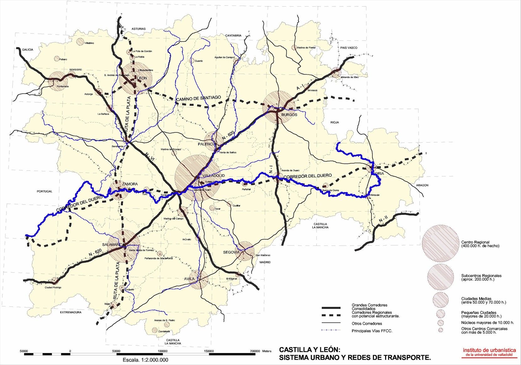
Castilla y León is a Spanish Region with 2.562.979 people (1991), spreaded on 94.000 Km2 —the largest Region in the E.U.—. This Region has lost population during the three last decades and today has a medium density of 25 hab./Km2 —Spain has 78,1 Km2, in Castilla y León the 6,6% of the Spanish people lives in the 18,76% of the total Country territory—. This is the most important condition in a Region where the city system is very weak, basically shaped by the nine provincial capitals and with large farming lands —about the 30% of the people lives (1991) in villages smaller than 2000 hab.; Castilla y León belongs to the E.U. regions objective nº 1, with less of the 75% european medium rent—. The urban network has about 100 km. distance between the closer cities. Valladolid, the bigest regional city and since 1983 the regional capital, is settled in the regional centre and in an strategic point in the NorthWest of the Iberian Peninsula, quasi—equidistant to the other regional cities. Valladolid, Segovia, Zamora and Palencia are historical and inland cities.
In this context of low density the attention to landscape is a key for regional planning. The complexity of the Spanish relief and climate give rise to a variety of landscapes, from the mountains to the low-lying fertile areas near rivers and from the extensive plains of the large inland plateau —the Meseta Central, which belongs our region— to the peculiarities of the coast. Though the forest is a constant throughout Spain, the predominant feature is shrubland, which exceeds even cultivated land in area. Wide expanses of low population density and the transformation of rural zones make the natural potential of large areas of land more and more evident. A future in which the diversity and wealth of Spanish landscapes provides an alternative to barren lands and the devastating effects of the arid climate may therefore be imagined.
The Regional Authority decides to request a new regional planning instruments, in our case the Directrices de Ordenación del Territorio, as an innovative system of guidelines for the central cities and the municipalities in their environs. They justify, the necessity of regional planing for develop functional areas, where rural and urban are progresivily more related, and where the current supra—municipal character of urban -suburban- growth, generates spilovers and great consecuences in land use. The start point is a situation where the usual local planning can not arrive to global solutions.
We are, in the Instituto de Urbanística de la Universidad de Valladolid, developing four of this regional plans in four urban and rural regions of Castilla-León: the metropolitan area of Valladolid and the city and the surroundings municipalities of Segovia, Palencia and Zamora —three historical little cities, about 60.000 people, with different position and character.
Valladolid is the regional capital, with 400.000 people in an emergent metropolitan area, and with a transformation in the urban model, subjected to a process of suburbanitation without precedents, but also in a process of consolidation in its role in the northwest Spain, fiting in with its real urban rank.
Segovia is an Historical city, World Heritage, and with a great landscape, close the Madrid metropolitan area. The attraction of Segovia is clear for leisure and holiday housing, but also in the futur for the decentralitation of some activitis from Madrid. But now there are a lot of problems about the urban growth in the little villages around the city.
Zamora is a city in an excentric position and with strong problems caused by the lack of contact with the big corridors of transport. Zamora suffered the porblematic relation between Spain and Portugal, only activated since the acces to the European Union.
The arrival of new regional networks is in the future of these cities, with new infraestructures and new opportunities of development in a region with a low level in its economy. One of the most important future infrestructures is the High Speed Train, connecting Madrid and its hinterland with Segovia —only in 20’-, Valladolid —only in 60’-, and also Palencia and Zamora, and finished in the 2003/5 The new rail layout on the urban areas is now in discussion.
One of the scopes of our work is to define any guidelines for the urban growth from the territorial perspective, searching around the probable urban change in the next two decades. The conditions of location, the incredible growth of urban land uses, the indecisiviness in demographic growth, the change in the work conditions and lifestyles, looking for open spaces, probably increase with the future infrestructures.
Figure 1. Urban System in Castilla y León.
2. The emergence of a new urban reality in inner mediums cities. The end of the "centro-periferia" model.
The current context of urban growth is in a way from the compact —mediterranean- model to an sprawll model, with a lot of spillovers in the traditional landscape —rural or natural. The location conditions are progressively more open and the control of urban land uses is in a permanent conflict with the market hegemony and the will of economical growth. We can think in the overcoming of the post-war urban model of "centro-periferia", interpreted in terms of a central and compact city, in continuity with the historical urban fabric, and a perifery with industry and only some subsidized housing or residential areas in the countryside for gentry.
But nowadays a lot of people are living, shopping and working in the urban fringe. This phenomenon was in Spain a particular condition of the metropolitan areas, and now we can also see it in the medium and small cities. The suburban process stay with othes changes in live style and in the urban patterns in our medium cities:
-The consumption of land is always increasing for new urban uses without demographic growth.
-In the countryside, some rural areas have a great vitality and economical development, but the main part of the rural realm is in a continous process of decay.
-A lot of rural land and villages are living in an economical mirage: the agriculture is subsidized, the new economy does not arrive, the rural tourism does not run and the cultural and the natural heritage is a resource only in singular cases…
-The cultural heritage is a topic in Castilla y León. There is a real cultural richness, but the development associated goes slowly.
-The increase of suburban growth linked wiht new life-styles, with 4x4, golf courses and the search of natural spaces for living -rivers, woodlands, etc.-, coexist with the increase of housing for holidays and with new business areas. The car is the dominant transport system. The central city is congested, but the reatil in the historical city is blocked by the peripherical shopping centers….and always the explanation is related with the market and with spontaneous phenomana.
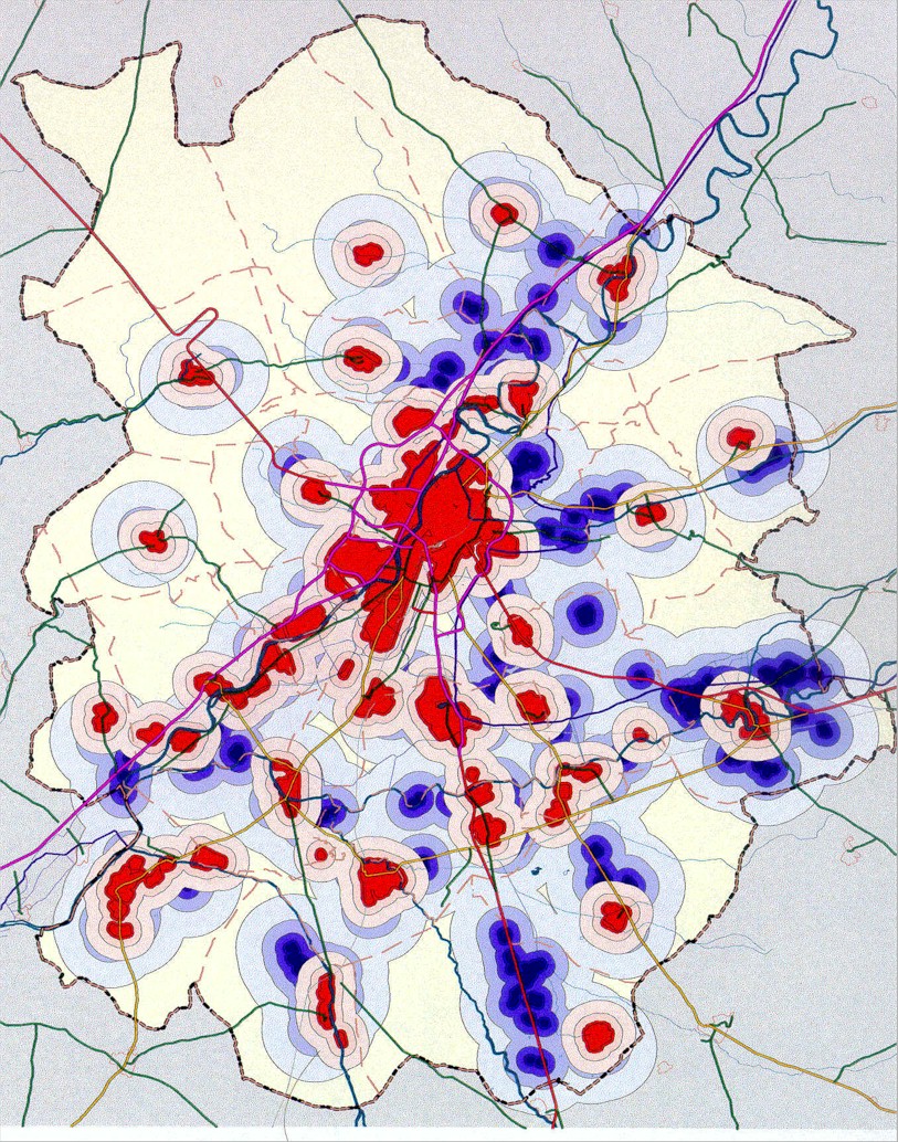
-And the context of the public action is to create an more and more isomorphic and isotropic system of roads and highways, offering new opportunities of location. This is paradigicaly dramatic in a context of low density, because the spontaneous location, without planning, generates a metastasis in land uses: a lot of urban development spreaded in the territory. Here it is caractheristic the tansformation of old farms in residential areas, without continuity, only supported in the ease introduced for the concentration of land in one only owner.
Figure 2. Valladolid and environs, growth metastasis.
3. Regional planning in an indeterminated context. Flows of urbanites in the rural without density disappearing.
The compact city is in time with a new kind of urban sprawl, unkown in the Castilla y León cities, traditionally linked with the historical mediterranean city and its growth, in a continous form with mixed—uses. In spite of these cities are not a ripe metropolitan areas, the city and its environs are in a process of suburbanitation. We have two initial conditions: the congestion of central city and the low density in a big territory, with a clear delay in the public investments in infrastructure, allways pomised. For this, the understanding of the territory model begins interpreting five situations:
-The central city as the locomotive, improving its congestion and creating new infraestructures in the regional level.
-The urban continous, articulated from the central city.
-The urban discontinous, estructured in the existing little towns and villages like centers of local facilities.
-A new local centrality, associated with the towns system closer the central city, resolving in transition the county facilities.
-The global and local landscapes, driving the urban growth to compact forms, controlling the urban sprawl, and structuring the land uses fron the landscape values -natural and cultural.
Our work is founded in two system of references: one linked with the municipalities character and the other structured in the physiography conditions, allways like analysis conclusion. The supramunicipal character of work justifies an urban model as a global services giving system, inside the quality of life idea, and we need more rationality to manage the services related with mobility, water, wastes and pollution.
The main scope of Directrices is to introduce in this area a coordinate planning to manage an undetermined growth, founding in some strategical actions context and in the environmental the basis for a sustainable development. The GIS analysis will permit the data integration, a comprehensive vision usefull for planning. The Directrices drafts, after an important territorial inventory and a methodological effort, are oriented to resolve the main structural and growth management questions, as an open system, and to understand the city and its region as a related landscape. But we need understand well what is quality of life, in the compact city and in the urban fringe.
What kind of sustainaible place are Valladolid, Palencia, Segovia or Zamora?. Sustainability in the compact city needs control the congestion cost, and in the urban fringe moderate the spillovers. The relations between dwelling and work must be supported by the existing and programed infraestructures. This relation, in the whole area, is the first scope. The urban sprawl could be regulted with a coordinate planning and the regional planning is the first step, establishing a similar status in adjoining municipalities. We have defined three local systems, very related, in order to establish futur decissions:
-a general transport and mobility system, defining the accessibility in intensive use zones.
-a basic facilities system, founded in the existing towns system, where the public investment is the foundation of envirnmental decisions linked with spatial planning
-a greenways network and a metropolitan park system, structuring the leisure and the recreational opportunities and the correspondence with landscape protection and people amenities.
The current urban growth is an oportunity to relate lands uses to the adequate places, facing growth limits in saturated areas and incorporing lanscape values. To manage private and publics lands to strike a balance between economic growth, social equity and environmental suitability is only possible involving the governement regulatory power in the land use conditions to achieve physical, functional, social, environmental and economic goals. The Directrices is a group of related strategies and tools for this, a way to establish an urban futur model, no rigid, only as structural reference in the territory arrangement, to think estrategicaly. Some rules and singular programs —natural and cultural heritage, farmlands, landscape character, protection of urban stress, facilities...— are related with teh specific conditions of every minicipality and with every landscape unit. The dynamism in suburban phenomenon can be reoriented in more compact solutions, protecting the nature with growth managemants concepts: growth limits in saturated areas; subdivisions controls and permit limits; zoning controls related with process and performance controls; landscape values protection; infrastructure conditions —water supply, watter pollution and sewer system, waste traitment and energy rationality—, controlling acces to public facilities and requiring new facilities; the contol of accesibility in natural spaces and critical areas; and tax coordination between municipalities, linked with expenses in public services. It is not necessary to create new authorities, the subregional plan can be a powerfull instrument for the existing administration, in local and regioonal level.
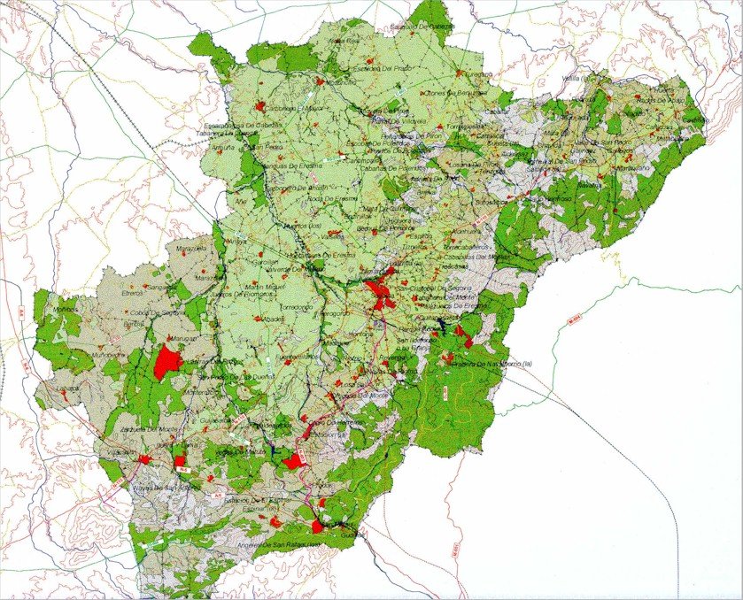
Figure 3. Segovia and environs, land uses —image form GIS-.
4. The landscape as argument, a new logic of structuring the form in the City-Region.
The Castilla y León cities and their environs are in a current suburban process wich belongs to a new urban model, involving urban, rural and natural spaces. The concept of City—Region is useful here. It is possible to consolidate the local identity —historic, cultural and landscape assets— and the belonging sense in people. When we began to work we were in the conviction that the environmental topics were the principal oportunity in the futur arrangement of this large space, not only by the necessity to resolve the real environmental problems, but also by the possibilities of landscape itself, understanding as well as were possible the global conditions of this space.
We can work in the identity of place but it is more difficult to work in creativity or in the real improving of richness. We must believe that the first belongs to the second. With the local potencials for economical development, the environmental resources permit to consider the quality of life in the urban system as a source of competitive advantage and attractive for investments.
We can remeber the concept of Region in Lewis Mumford and others, where regionalism concerns the imaginative recovery of place and implied both a sense of place informed by the scientific and imaginative exploration of the environment and an idea of culture linked to the geographic association of place. City—Region as global sustainable development model managing the urban growth and protecting the landscape values. If the city system become more efficient, we can resolve the urban congestion improving the public transport system, we can improve the strategical infrastructures -with a selective synergy of projects— and we can manage density resolving edge problems and reorienting tha urban sprawl to the compact towns and villages system. But we need only planning, or technical efficiency, we need consensus, continuity in the action and active process to involve the people. A Social City Region model where there is priority for the public interest, in the inner city and in the remote rural areas.
The landscape potential in recreational opportunities could be here the key of a complementary structural item: greenways networks, founded in historical network, like the Cañadas, regional park systems, related with publics forest and with the rivers and mountains, natural areas protected, etc. Valladolid, Segovia, Palencia and other Spanish Cities have forgoten the original links with Nature, but now the people aims a new relation with nature. We can rediscover the global landscape in the moment when the urban growth is occurring in the peripheral municipalities —on towns, villages or open spaces—.
We are working in the idea that lanscape structure must regulate the change in urban areas, managing its constraints to managing the infraestructure layout and the urban density. But to understand the lanscape is no easy. There are scientific, cultural and social values rarely involved in planning. The landscape has a formal structure, and this structure will be related with the urban networks and facilities to prepare the urban growth in an adaptative way. This conception of urban fitness is not conservative. The landscape is allways in a creation process, is imperfect and fragile, but has form. The landscape in the urban realm can not became the slave of carterpillers. We can present the first ideas, with graphics and maps, to understand our vision of the urban future in these cities and in their urban regions.
In Spain we do not have tradition in Landscape Planning or in Ecological Planning applied to urban or regional planning. The environmental analysis, the technics of suitability analysis —to define the best areas for a potential land use determining the deep factors and conditions— or some concepts applied in planning like the landscape assessment, adaptation, resource or capability, were unusual in our urban planning tradition. The Nature has been present in planning only in the analisys and protection of the most singular places, with few references to urban growth. Now the plans are begining to understand the transformation in land uses facing the urban and the non urban realms in comprehensive ways. The people realizes that Nature is a category also in the city. But we need also work in our culture of the artifact, in the architecture of our urban objects, with new ideas, in an adaptative way, looking for new solutions.
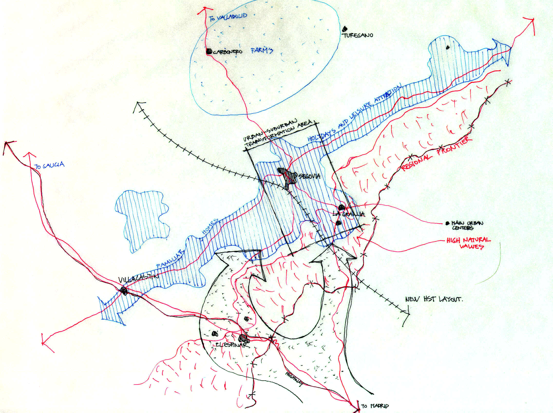
Figura 4. Segovia and environs, working scheme.
References.
-Avance de Directrices de Ordenación Territorial de Valladolid y Entorno . (1997),
Documento del Instituto de Urbanística de la Universidad de Valladolid.
-Blowers, Andrew. (1993), Planning for a sustainable environment. London: Earthscan Pub., a report by the Town and County Planning Association.
-Castells, Manuel, (1998). Entender nuestro mundo. Revista de Occidente nº205, Mayo.
-de las Rivas Sanz, J.L. (1998), Valladolid and its Environs: Sustainable Basis in a Proposal of City-Region, in "Creating Sustainable Places", Herberger Center for Desing Excellence, Arizona State University, Tempe AZ.
-de las Rivas Sanz, J. L., (1999). La Naturaleza en la Ciudad—Región: Paisaje, Artificio y Lugar, Revista URBANA nº 24: pág. 11-35. Caracas.
-Gotmann, J. y Muscara, C. Eds., (1991). La città prossima ventura, Laterza, Roma.
-Hall, Peter (1998), Cities in Civilization. Culture, Innovation and Urban Order, Weidenfeld & Nicolson, London.