The purpose of this study is to represent the possibility of new the Internet technologies for the interactive citizen participation in city planning sharing the virtual urban space among users on the cyberspace. The Internet is used for publishing the information about urban planning process by most local governments, on the other hand the difficulty to share the 3D image of the city among planners and citizens is being indicated. With these points as background, we examined the features of some new Internet technologies applied them for interactive citizen participation.
With the advance of the information technology and spread of the Internet, the number of the local government in Japan that use the Internet as a tool to communicate with citizen are rapidly increasing in recent years. Until now, the web site managed by published local governments information only with images and a characters, because of some technical problems. But now, some user can choose their favorite information from various menus and acquire them. Some local government made an advanced trial to connect to the urban planning process applying these technologies. Though occasions for participation and discussion are increasing and information are published on the web, it is difficult for citizens to understand their own space image by characters and 2D figure based communication. These are the barriers to promote the urban planning through the Internet. So, we research of the information sending style of the local government of our country in the urban planning field. Moreover, we investigate the characteristics of the present Internet technology which can be applied to the urban planning, and development of the interactive communication system for urban planning using Web3D which actually combined some new technologies.
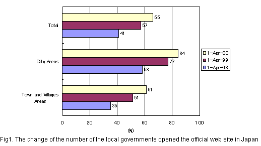
There are local governments about 3,000 in Japan, and official survey reports that 70% of them have their official web site to publish public information in April, 2000.(Fig.1)
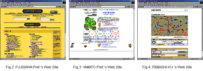
The web site that publishes the information of the urban planning is yearly increase. At present stage, we can see the published planning process and explanation of technical terms about urban planning, and citizens' comments are gathered on BBS (bulletin board system) on text and 2D figure based WebPages. We will introduce some typical examples. Fujisawa city in Kanagawa Prefecture is the advanced local government taking in Internet technology actively. This city establishes "the citizen electronic conference room". At present, about 1,500 general citizens participate in this site. They are exchanging active argument on the Web site. (Fig.2) Administration is collecting inhabitant's live voices widely. Next, Yamato City inside the same prefecture, this local government collects opinions from the inhabitant widely using the BBS and the E-mail. Then, those opinions are actually made to reflect on the decision process of the city master plan. (Fig.3) Additionally, a web site related to city planning outside the country, information such as city planning literature, city planning NPO, a city planning consultant data base are being collected in the page that it was named as the "Cyber Planning Projects". Like this, the environment that can be studied about the city planning for the citizen is being prepared. Moreover, there is a few local government that technically advanced more. Itabashi-ku in Tokyo Metropolis opened an advanced technology such as WebGIS which the reference of the address and indication of a map of the result are made to the public widely. (Fig.4)
By using Internet technology, citizens can get information about planning process for the future image of their own town and participate in the discussion on the web anywhere, anytime. However, as for the urban planning, the place of the argument that an inhabitant's opinion was related to the space image of the city should be necessary. But, these environments on the web site haven't been realized yet. As for these, it has been getting possible to solve it by combining the new Internet technology and using it. Each technology of the tip where it can be applied to the urban planning is introduced in the next chapter.
Recently, Internet technology improves remarkably. The various visualization technologies to grasp a space image are developed in addition to the expression with the character and the static image. A 2D map is necessary to grasp the place of the developing area and the user's present position when it thinks about use with the urban planning. Moreover, 3D expression technology is indispensable to grasp on visually the exterior of the applicable building, a change in the position, harmony with the circumference environment. So, the new technology that can be applied to the urban planning is introduced in the following.
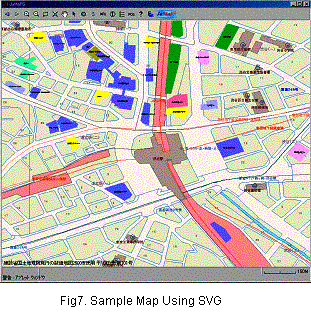
The image of the vector format can be handled on the web site by using SVG which made based on XML(eXtensible Markup Language) which diffusion proceeded through recently. We can express 2D figure data such as a map which has been used by SVG more flexibly. The map service realized at present need combine many sheets of images to display a map. This method is the main style in the present. In this service, we must repeat the request for the Web server and the display of the result at every the movement of the map and the change in a scale. As for these, there is a problem in the response speed. On this point, SVG is easy to handle because it is a Vector-based format data. It is very suitable for the use that a reference and the change of the scale such as GIS(Geographic Information System) technology. (Fig.7)
The advantage of SVG is enumerated in the following.
- The preparation of the figure is easy.
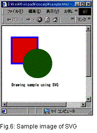
- The structure of the document is easy. (Fig.5,6)
- An image is high quality.
- File size is small. (Table 1)
<?xml version="1.0"?>
<!DOCTYPE svg PUBLIC "-//W3C//DTD SVG 20001102//EN"
"http://www.w3.org/TR/2000/CR-SVG-20001102/DTD/svg-20001102.dtd"><svg width="100" height="100">
<rect x="20" y="20" width="80" height="80" style="fill:red;stroke-width:5;stroke:blue"/>
<circle cx="100" cy="100" r="45" style="fill:green"/>
<text x="20" y="170">Drawing sample using SVG</text>
</svg>Fig.5 Sample source of SVG
Table 1 The comparison of the image file size by the displayed size (Unit:byte)
SVG SVG
(GZIP Compressd)PNG8 PNG24 GIF JPEG
(High Quality)JPEG
(Nomal)JPEG
(Low Quality)BMP 600x600
1,096
578
32,716
68,223
46,912
81,064
37,448
25,310
1,080,056
300x300
1,096
578
19,048
63,255
23,652
30,807
15,718
10,380
270,056
200x200
1,096
578
13,311
46,767
14,819
18,559
9,302
6,237
120,056
100x100
1,096
578
5,751
18,913
5,921
7,095
3,570
2,466
30,056
50x50
1,096
578
2,363
7,079
2,360
2,532
1,315
974
7,656
25x25
1,096
578
972
1,453
824
908
609
528
1,256
5x5
1,096
578
247
215
152
534
425
417
136
1x1
1,096
578
140
124
43
512
408
408
60
Especially, it is very useful in the urban planning that display of a map of the large area should be necessary. But, there are some demerits from being new technology under the present condition. The demerits of SVG is enumerated in the following.
- Specifications are examination stages.
- Exclusive Plug-in is necessary to display.
- Data authoring tool isn't established.
- A data security is poor.
However, it can be used as the very powerful expression tool when these demerits improved in the future.
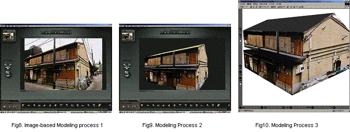
Image-Based Modeling is the processing technology that the figure of the 3D wire frame is arranged based on the image such as a photograph(JPEG, TIFF, PSD, GIF, BMP, PNG). A photograph is pasted automatically to the around figure of the wire frame, and it easily make the virtual building of 3D. When a figure is added and arranged more, a photograph changes to the 3D urban scene. CANOMA 1) developed by MetaCreation company to use this study is not the tool which pursued precision. But, the formed model and an animation are sufficient to visualize quickly. These data can be changed into the VRML format data, and a user can confirm a figure visually in the optional point of view. And, the color, shape, position of the figure can be modified freely. (Fig.8, 9,10)
The demerits of Image-based modeling are described in the following.
- An experience is necessary to trace a figure precisely and to arrange it in data authoring tool.
- A form is limited to library of the figure. Especially, It doesn't prepare for a curve form like a ball. Like this, a degree of dependence to the authoring tool is high in work.
These figure data (SVG, VRML) and character data by the BBS and the mail are managed by the DBMS(Data Base Management System) such as SQL Server, PostgreSQL. Contents of a user's opinion are made to link with ID of the figure data and the user ID, and they are stored to DBMS in time series. It becomes possible by this that the process of the plan decision is reproduced later. These functions are effective in the support of the urban planning. A city image is confirmed by applying this various new technology to the urban planning visually, and it becomes possible that information is exchanged on the Internet interactively. We think that it becomes the urban planning which is easy to be understood for the inhabitant by using these new technologies.
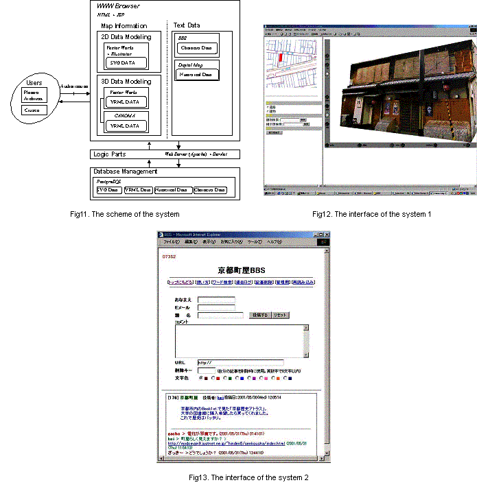
Now, we proceed with the development of new interactive communication system for urban planning which these technologies are combined mutually. It makes use of the characteristics of each technology described with 3 chapters, and we are aiming at the realization of the plan support system interactively that combined a space image to the character information. A figure 11 shows the functional relation of this system. Users can operate only on the screen of the WWW browser. User's position and an applicable area on the web browser are grasped with 2D map described above. A user's opinion is added with the character information on BBS and E-mail. These variety data are managed by DBMS. A figure 12 and 13 show the images of the system.
In this study, we investigated the present situation of the information publishing using WWW and pointed out the technical problems. It was found that the Internet isn't connected with the use that aimed at the plan support with the city planning under the present condition. So, we examined some new Internet technology applied them about in the Web-based system for interactive communication in planning. A lot of web sites tried to use Internet in the urban planning process. But, there is a fatal point for users to have common space image because they use only a character data and an image on the web. It was difficult for them to actively exchange their drawings of future town space. Our proposal is to reproduce the own city area on the Internet by exchanging each inhabitant's opinions by combining the advantage of the Internet technology. Though the visualization technology remains to be improved, we think these technologies will receive wide application in the future. The system that we develop could be an effective tool as a planning support system for the corroboration in the city planning. We think this system is useful for obtaining the consent of residents smoothly by future improvement about the function, contents and interface of our system.
1) MetaCreations International Ltd., http://www.metacreations.com
- Internet White Paper 2001,Internet Association of Japan, Impress Corporation,200
- The present condition and subjects of the city planning information interchange in the Internet age, Architectural Institute of Japan, 2000
- The possibility of the Internet use in the decision process of the urban planning, Keio University, 2000
- Software Design June-July, Gijyutsu-Hyoron Co., Ltd., 2001
- XML PRESS Vol.3, Gijyutsu-Hyoron Co., Ltd., 2001
- The World Wide Web Consortium, http://www.w3.org/
- W3C Scalable Vector Graphics, http://www.w3.org/Graphics/SVG/Overview.htm8
- Extensible Markup Language, http://www.w3.org/XML/
- Adobe Systems Incorporated, http://www.adobe.com/